

Annapurna Circuit Trek in April
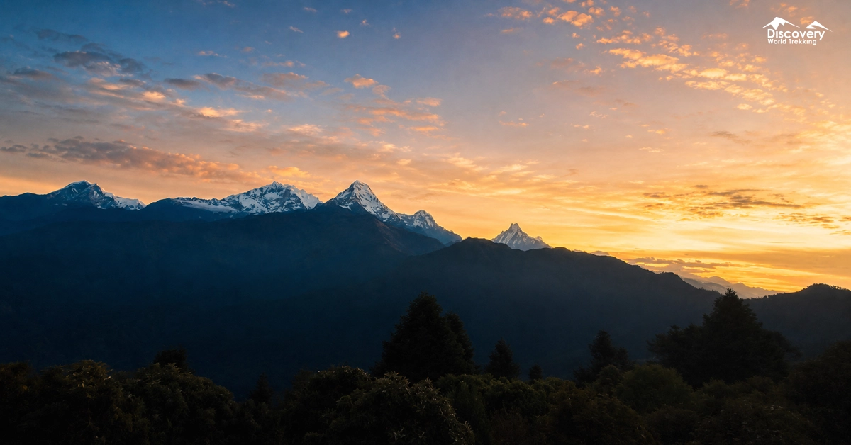
April is the most rewarding month for the Annapurna Circuit. The month lies at the peak of the spring season in Nepal.
In April, the season brings clear mornings, mild daytime temperatures, and excellent visibility across the Annapurna Mountain Range.
The thing that makes the Annapurna Circuit Trek in April special isn’t just the weather conditions but the rise in the number of trekkers along the trail. The popularity enhances the overall atmosphere of this once-in-a-lifetime opportunity.
Is April a Good Time for the Annapurna Circuit Trek?
April is an excellent month for the Annapurna Circuit because the trekking season is fully active from the lower valleys to the high pass.
Days become comfortably warm below 3,000 metres, while the higher route retains the crisp mountain atmosphere that defines a Himalayan journey.
The trail is particularly attractive during this month because each elevation offers a different seasonal character.
Around Jagat and Dharapani, fresh vegetation frames the Marsyangdi Valley. Around Chame and Pisang, pine forests open towards the Annapurna peaks.
Beyond Manang, the route becomes spacious, dry, and alpine, with snow highlighting the mountain ridges.
April is suitable for well-prepared first-time Himalayan trekkers as well as experienced walkers.
A carefully paced itinerary, especially one that includes an acclimatization day in Manang, allows the body to adjust naturally before the climb towards Thorong La.
| Factor | April Conditions |
| Weather | Mostly stable and dry |
| Mountain views | Usually clear in the mornings |
| Trail conditions | Mostly dry, with possible snow at higher elevations |
| Crowds | Moderate to busy |
| Accommodation | Open, but advance booking can help |
| Thorong La Pass | Usually accessible |
| Difficulty | Moderate to challenging |
| Best for | First-time and experienced high-altitude trekkers |
Why Trek the Annapurna Circuit in April?
April brings together the most enjoyable qualities of spring trekking.
1. Stable Spring Weather
April usually offers a pleasant daily rhythm. Mornings commonly begin with clear skies and crisp mountain air, creating ideal conditions for walking and photography.
As the day progresses, soft clouds may gather around the higher ridges, adding depth and movement to the Himalayan scenery.
At lower elevations, the air feels fresh rather than wintry. Around Manang, the atmosphere becomes cooler and drier, which suits steady uphill walking.
The spring pattern also makes early starts especially enjoyable, as trekkers can cover the day’s distance during the calmest and clearest part of the day.
2. Clear Himalayan Views
The circuit does not reveal all its mountains at once. Instead, the skyline changes as the trail curves around the Annapurna massif.
Annapurna II becomes increasingly prominent near Chame and Pisang, while Annapurna III, Annapurna IV, Gangapurna, Tilicho Peak, and the Chulu group dominate the Manang Valley.
After crossing Thorong La, Dhaulagiri rises beyond the Kali Gandaki corridor.
This gradual unveiling gives the trek a cinematic quality. Every few days, the mountains appear from a new direction, with different ridgelines, glaciers, and rock faces entering the view.
3. Rhododendron Blooms and Spring Landscapes
April gives the lower and middle sections of the trail a colourful spring identity. Rhododendrons brighten forest slopes, while new leaves, wildflowers, moss-covered rocks, and flowing waterfalls bring freshness to the valleys.
The scenery changes noticeably with altitude. Around the lower Marsyangdi Valley, terraces and subtropical plants surround the villages.
Near Dharapani and Chame, pine, fir, and rhododendron forests become more prominent. As the trail approaches Pisang and Manang, trees thin out and the landscape opens into broad valleys edged by snow-covered mountains.
The Annapurna Conservation Area contains more than 1,200 recorded flowering plant species, helping explain the remarkable botanical variety encountered across its many elevation zones.
4. Longer Daylight Hours
April’s longer days create a relaxed trekking schedule. Trekkers can begin early, maintain an unhurried pace, stop at viewpoints, enjoy lunch in a village, and still reach the next teahouse with time to rest.
The additional daylight is particularly valuable around Pisang and Manang, where the trail offers several scenic alternatives.
It also provides more flexibility during the acclimatization day, allowing time for a morning hike followed by an afternoon exploring Manang’s bakeries, monasteries, lanes, and traditional stone houses.
5. Cultural Experiences and Nepali New Year
The Annapurna Circuit passes through communities shaped by Gurung, Manangi, Thakali, and Tibetan cultural traditions. Architecture, language, food, farming practices, and religious monuments change as the route moves north.
Prayer wheels and Buddhist chortens become more frequent around Upper Pisang, Ngawal, Braga, and Manang.
After Thorong La, Muktinath Temple brings Hindu and Buddhist traditions together within one sacred landscape.
Farther down the Kali Gandaki Valley, Thakali villages introduce another distinct style of hospitality and cuisine.
Nepal doesn’t follow the Gregorian calendar. The country follows the Bikram Sambat calendar. That’s why Nepali New Year usually falls in the middle of April.
Travelling during this period may add a festive touch to the journey, with family gatherings, decorated homes, local meals, and a cheerful atmosphere in larger settlements.
6. Wildlife and Birdlife
The Annapurna Conservation Area supports 105 recorded mammal species and more than 500 bird species.
Blue sheep, Himalayan monals, lammergeiers, griffon vultures, and smaller alpine birds are among the species associated with the region.
Early mornings and quieter trail sections provide the most enjoyable opportunities for wildlife observation.
Annapurna Circuit Weather in April
April weather develops differently across the route because the trek crosses an enormous vertical range.
Early April Weather
Early April preserves more of winter’s visual character at higher elevations. Snow often remains visible around the Chulu peaks, Gangapurna, Tilicho Peak, Thorong Phedi, and the approaches to Thorong La.
Lower sections are already entering spring, creating a beautiful contrast between green valleys and white mountain ridges. Early April therefore suits trekkers who enjoy stronger snow scenery while still benefiting from the opening spring season.
| Elevation Zone | Typical Daytime Temperature | Typical Night-Time Temperature |
| Lower elevations: 800–1,500 m | 20°C to 27°C | 8°C to 14°C |
| Middle elevations: 1,500–3,000 m | 12°C to 20°C | 1°C to 8°C |
| Alpine elevations: 3,000–4,000 m | 6°C to 14°C | -5°C to 2°C |
| High-pass zone: 4,000–5,416 m | -2°C to 7°C | -12°C to -5°C |
Mid-April Weather
Mid-April often presents the season at its most balanced. Rhododendrons and forest vegetation are well developed in the lower regions, village life is active, and the route has a sociable trekking atmosphere.
Morning skies frequently provide detailed mountain views, while the growing daylight allows trekkers to enjoy viewpoints without rushing. Manang also feels lively during this period, with trekkers using the village as a comfortable acclimatization base.
| Elevation Zone | Typical Daytime Temperature | Typical Night-Time Temperature |
| Lower elevations: 800–1,500 m | 22°C to 29°C | 10°C to 16°C |
| Middle elevations: 1,500–3,000 m | 14°C to 22°C | 3°C to 10°C |
| Alpine elevations: 3,000–4,000 m | 8°C to 16°C | -3°C to 4°C |
| High-pass zone: 4,000–5,416 m | 0°C to 9°C | -10°C to -3°C |
Late April Weather
Late April brings warmer daytime conditions to the lower and middle route. Forests become greener, agricultural fields appear more active, and waterfalls carry the freshness of spring.
Higher areas continue to offer cool, clear mornings. Later in the day, cloud formations may build around the mountains, creating dramatic light for photography. Starting early allows trekkers to enjoy both the clearest views and the most comfortable walking temperatures.
| Elevation Zone | Typical Daytime Temperature | Typical Night-Time Temperature |
| Lower elevations: 800–1,500 m | 24°C to 31°C | 12°C to 18°C |
| Middle elevations: 1,500–3,000 m | 16°C to 24°C | 5°C to 12°C |
| Alpine elevations: 3,000–4,000 m | 10°C to 18°C | -1°C to 6°C |
| High-pass zone: 4,000–5,416 m | 2°C to 10°C | -8°C to -2°C |
Average Temperature in April
Thorong La Pass Conditions in April
Thorong La is the highest and most memorable stage of the Annapurna Circuit.
In April, the route is generally accessible, and the trail is actively used by guides, porters, lodge operators, and trekking groups. Snow often remains around the upper slopes, adding a genuine high-Himalayan character to the crossing.
The day normally begins before sunrise from Thorong Phedi or High Camp. Headlamps illuminate the first section while the eastern sky gradually brightens behind the mountains.
The ascent follows a steady zigzag trail past small rest points until prayer flags and the Thorong La sign appear at the pass.
From the top, the landscape opens in both directions. Behind lies the Manang Valley and the Annapurna range; ahead stretch the dry hills of Mustang and the distant Dhaulagiri massif.
Trail Conditions Along the Annapurna Circuit in April
The trail changes continually in April, offering forest paths, stone stairways, broad valleys, suspension bridges, alpine tracks, and high-pass terrain.
Besisahar to Dharapani
The opening section follows the Marsyangdi River through warm valleys, terraced farmland, waterfalls, and traditional settlements. Jagat, Chamje, and Tal introduce the rhythm of village-to-village trekking.
Tal is especially memorable because it occupies a wide, flat river basin beneath steep cliffs. The trail then continues through Karte and Dharapani, where the landscape begins shifting from subtropical vegetation towards cooler mountain forest.
Dharapani to Chame
From Dharapani, the route climbs through Bagarchhap, Danakyu, Timang, and Koto. Dense pine and fir forests surround the trail, while Manaslu and Annapurna II begin appearing through openings in the trees.
Timang provides one of the first expansive Himalayan viewpoints. Chame, the administrative centre of Manang District, offers comfortable lodges, bakeries, shops, and riverside hot springs.
Chame to Manang
This section reveals the scale of the upper Marsyangdi Valley. The trail passes the dramatic Paungda Danda rock face before reaching Pisang.
The route through Upper Pisang, Ghyaru, and Ngawal provides elevated views across the valley. It is longer than the lower route but rewards trekkers with traditional villages, old monasteries, and uninterrupted views of Annapurna II, III, and IV.
From Ngawal, the trail descends through Braga, home to an ancient monastery, before continuing to Manang.
Manang Acclimatization Area
Manang is much more than a rest stop. Its position beneath Gangapurna and Annapurna III makes it an ideal base for exploring the valley while supporting natural acclimatization.
A morning hike towards Gangapurna Lake, Praken Gompa, or a nearby ridge allows trekkers to gain elevation before returning to sleep in Manang. The afternoon can then be spent walking through the old village, visiting a bakery, or observing the changing light on Gangapurna Glacier.
Manang to Thorong Phedi or High Camp
Beyond Manang, the trail rises gradually through Gunsang, Yak Kharka, and Ledar. The valley becomes wider and quieter, with juniper shrubs, alpine grassland, and open views towards the Chulu peaks.
Blue sheep are sometimes visible on the surrounding slopes. The route then crosses the river and climbs to Thorong Phedi. Trekkers staying at High Camp continue up a shorter but steeper section, gaining a commanding view over the valley.
Thorong La to Muktinath
After reaching Thorong La, the route descends towards Chabarbu and Muktinath. The scenery changes quickly from snow-edged high-pass terrain to the ochre, brown, and gold hills of Mustang.
Muktinath is a sacred destination for both Hindu and Buddhist pilgrims. Its temple complex, water spouts, monasteries, and surrounding mountain views make it a meaningful place to conclude the crossing.
Muktinath to Jomsom and Beyond
From Muktinath, the circuit continues through Jharkot and Kagbeni. Kagbeni’s mud-brick houses, narrow lanes, monastery, and position beside the Kali Gandaki River give it a distinctly Tibetan-influenced character.
The route then reaches Jomsom, with opportunities to continue towards Marpha, Tukuche, Tatopani, Ghorepani, and Poon Hill. Extending the trek through these villages preserves the circuit’s full transition from high desert back into forested hills.
Tilicho Lake in April
April is one of the most favourable months for trekking to Tilicho Lake, with warmer daytime conditions, longer daylight hours, and improved teahouse availability.
Snow may still remain around Tilicho Base Camp and the final ascent, especially during early April. The lake can appear partly frozen before gradually opening as spring temperatures increase.
The route beyond Khangsar crosses steep and exposed slopes. Melting snow can make some sections muddy or unstable, while shaded areas may remain icy during the morning.
Most lodges along the route are normally operating, but rooms can fill quickly because April is a popular trekking month. Advance coordination from Manang or Khangsar is recommended.
Trekkers should begin the lake climb early to benefit from clearer morning weather and firmer trail conditions. A guide, trekking poles, sun protection, warm layers, and microspikes remain useful even during spring.
Annapurna Circuit Packing List for April
An April packing list should be built around layers.
- A moisture-wicking base layer manages warmth during uphill walking, a fleece provides insulation during breaks, and a down jacket adds comfort in the evenings.
- A waterproof shell, trekking trousers, thermal leggings, warm gloves, a beanie, a sun hat, and quality trekking socks complete the clothing system.
- Broken-in hiking boots provide support across stone paths, forest trails, and alpine terrain.
- Useful equipment includes trekking poles, a headlamp, UV-protective sunglasses, sunscreen, lip balm, a reusable water bottle, water purification supplies, a cold-rated sleeping bag, and a power bank.
- Packing cubes or dry bags keep clothing organised. Frequently used items, water, snacks, sunscreen, camera, gloves, and a light jacket should remain accessible inside the daypack.
- Microspikes can be carried when recent snow conditions make them useful around the pass.
| 📄Ready to Pack for Your Annapurna Circuit Trip? Download Checklist |
Safety Tips for Trekking in April
A comfortable Annapurna Circuit begins with a gradual itinerary. Spending two nights in Manang gives the body valuable adjustment time before continuing towards Yak Kharka and Thorong Phedi.
Hydration, regular meals, steady breathing, and an even walking pace support energy throughout the day. An early start is especially rewarding on the Thorong La crossing because the morning atmosphere is calm and the sunrise gradually reveals the surrounding peaks.
A licensed guide adds local knowledge of trail conditions, village logistics, weather patterns, and the most suitable overnight stops. Under the Nepal Tourism Board’s current TIMS provision, the Annapurna Circuit is listed among the routes requiring foreign trekkers to travel with a licensed guide and carry a trekking-agency-issued TIMS card.
Keeping one flexible day within the itinerary also allows more time for Manang, Muktinath, Kagbeni, or another favourite location.
FAQs
Is April a good month for the Annapurna Circuit Trek?
Yes. April combines comfortable spring walking, open teahouses, flowering lower valleys, clear morning views, and an active trekking atmosphere. It is particularly rewarding for travellers who want to experience both green landscapes and snow-covered high mountains within one journey.
How cold is Thorong La Pass in April?
Thorong La has a crisp high-altitude climate, especially during the pre-dawn ascent. Temperatures commonly remain below freezing around the top in the early morning, while sunshine brings greater warmth during the descent. Thermal layers, gloves, a down jacket, and wind protection create a comfortable clothing system.
Do I need a guide for the Annapurna Circuit?
The Nepal Tourism Board currently includes the Annapurna Circuit among the routes where foreign trekkers require a licensed trekking guide and a trekking-agency-issued TIMS card. A guide also coordinates accommodation, monitors the daily route, shares local knowledge, and enriches cultural interactions.
Are teahouses open in April?
Yes. April is a fully active trekking month, and teahouses operate across the route. Larger villages offer a broad choice of lodges, while smaller high-altitude settlements provide warm dining spaces, nourishing meals, and welcoming places to rest.
Are microspikes required in April?
Microspikes are condition-specific rather than a standard requirement for every April departure. They are useful when compact snow is present near Thorong La. A trekking guide can review the latest trail conditions in Manang and recommend whether carrying them will add comfort to the crossing.
Plan Smarter, Trek Better
Connect with our local expert for honest recommendations, personalised guidance, and insider tips to make every step of your adventure count.

Get our free Nepal travel guide filled with expert insights, local tips, and essential planning advice.